Login to your account!
Join the World's Largest Web App Marketplace!
Great to see you here!
Let’s set up your account in just a couple of steps.
Forgot password?
Enter your username or email to reset your account.
WordPress Plugin for Google Maps - WP MAPS PRO
By : flippercode Published On Saturday, July 27, 2024, 12:46 In WordPress
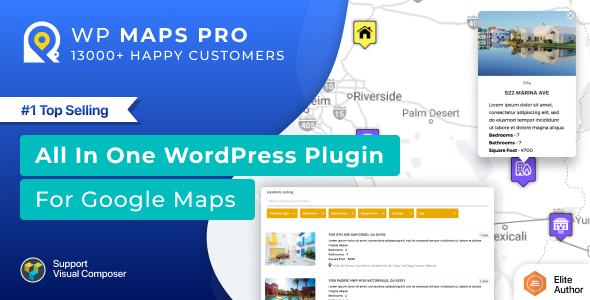
This feature-rich WordPress plugin for Google Maps is designed to be user-friendly and straightforward, providing an effortless way to incorporate customizable Google Maps into your WordPress website. With its powerful features, you can display custom post types and custom fields on Google Maps, create custom filters for listings and marker filtering, search for locations within a radius or based on the user’s location, and many more features.
Take a Quick Look

Benefits
- Save Time: Say goodbye to the hassle of dealing with Google Maps APIs and save your valuable time.
- Page Builders compatibility: This plugin is compatible with popular page builders: Elementor, Divi Builder, Visual Composer, and Gutenberg.
- Expert Support – Our team of experts provides dedicated support to our customers, ensuring that any issues are resolved promptly.
- User-friendly – This plugin is easy to use, with a simple interface that allows users to quickly create and embed maps on their website.
- Quick and Easy Setup: Love our live demos and want to replicate them on your website? Simply export the configuration file from our live demos and apply it to your site. Setting up your Google Maps has never been easier!
Features
- Easy filtering: Filter locations by custom fields, taxonomies, and location data. Create multiple filters using the backend.
- Display posts: Display posts, pages, or custom post types on Google Maps. You can display multiple post types on a single map.
- Assign locations: Assign a location to your post easily using the meta box or your own custom fields. You can use the Advanced Custom Fields plugin to assign a location to your post as well.
- Display post information: Display post information such as title, content, excerpt, featured image, categories, tags, custom fields, or custom taxonomies in an info window. You just need to use placeholders to display this data.
- Customizable post listing: Display posts listing below the map and show post information in the listing. You can customize HTML easily to integrate your own design.
- List display options: Display posts or locations below the map in a grid or list format. Visitors can switch formats at the front end.
- Custom marker details: Add any number of details in location or marker details and display them in an info window easily. E.g fax, phone, email, website, etc.
- CSV import: Import unlimited location data from CSV. You can import any number of fields in the location. Assign categories to your location using CSV. All CSV delimiters supported.
- Filter by category: Assign multiple categories to a location and allow visitors to filter by categories.
- Clickable markers: Choose to redirect to a location or display an info window message on marker click for both posts or manually added locations.
- Listing module: A complete listing module to filter, sort, print, and advanced search box to filter posts or locations by zip, address, city, country, post title or location title, and categories.
- Ajax search: The listing module is Ajax-based for the fastest search experience and usability.
- Radius search: Search posts or locations nearby within a certain radius. Customize radius settings in the backend.
- Filter by category: Filter locations/markers by category on the map. Ability to filter multiple categories at once.
- Sort listing: Sort the listing by title, address, or category in both ascending and descending order.
- Print option: Print a filtered location listing. You can control print options via the backend.
- Custom placeholders: Placeholders to modify location listing data without any programming.
- Customize options: Enable or disable the search form, category filter, print option, and sorting options in the backend.
- Pagination support: The listing module is pagination supported. You can decide # of posts or locations per page using the backend setting.
- Route directions: Ask for the start location and end location from visitors to show route directions. Click on the marker to automatically fill start location. Get driving, bicycling, walking or transit route information.
- Unit conversion: Visitors can get route directions in both miles and kilometers.
- Location input options: Display start location input as a textbox or select box filled with your locations. Display end location input as a textbox or select box filled with your locations.
- Default locations: Ability to display default start and end location in directions tab.
- Google Places API: Get nearby places within a certain radius using the Google Places API.
- Circle display: Display a circle around amenities found using the Google Places API.
- Enable marker clustering for multiple locations with 10 available styles.
- Apply marker clustering to posts and locations that update automatically with filtration.
- Choose marker cluster icons and mouseover icons for better user experience.
- Customize marker cluster grid size and max zoom level.
- Create multiple routes with assigned colors, waypoints, and optimized routes for the best path.
- Customize Stroke Color, Stroke Opacity, Stroke Weight, Travel Modes, Unit Systems, Start Location, End Location, and Waypoints for routes.
- Make routes draggable and suggest optimized waypoints.
- Assign waypoints to routes with a searchable location list.
- Draw multiple clickable circles, rectangles, polygons, and polylines with infowindows and redirecting capabilities.
- Create your own custom Google Maps styles for roads, labels, and geometry.
- Fetch locations from external sources with automatic latitude, longitude, city, country, state, and zip code assignment.
- Manage parent-child categories with assigned custom markers or choose from over 500 ready-made markers.
- Customize infowindow message body with placeholders and modify contents via hook using programming.
- Apply Bounce and Drop Animation to markers for better visibility.
- Display multiple KML/KMZ layers, fusions tables, real-time traffic, bicycle path information, and physical maps on the same map.
- Set properties such as height, width, zoom level, map type, and scrolling wheel. Fully responsive maps that adjust according to device.
- Center the map based on the visitor’s current location.
- Display a circle around the center location and customize its properties.
- Assign multiple locations using searchable listings that are paginated for hundreds of locations.
- Show/Hide Zoom Control, Full Screen Control, Map Type Control, Scale Control, Street View Control, Overview Map Control, and set their position.
- Display Street View of the location with customizable POV Heading and POV Pitch.
- Display overlays with customizable border color, overlay width, overlay height, font size, border width, and border style.
- Limit panning and dragging with limit panning settings.
- Display GEOJSON data using URL easily.
- Display Google Maps in sidebars using widgets and add multiple Google Maps on a page with their own properties.
- Display categories, directions, routes, and nearby tabs together on a Google Map with location counts and sorting.
- Keep backup of locations, routes, maps, and categories with assigned permissions to users.
- Ability to use External Database or Sources to add markers on Google Maps using the new filter wpgmp_marker_source.
- Multiple Google Maps for WordPress – Enhance your website’s user experience by allowing your visitors to view multiple Google Maps on a single page with unique properties for each.
- Cross-Browser Compatible – This plugin is fully tested and compatible with all major browsers, including IE8, IE9, IE10, and more.
- Multilingual Support – Make your website accessible to a wider audience by offering multilingual support with .po files.
- Multisite Enabled – Activate this plugin network-wide on your multisite setup with ease.
- Custom Gutenberg Map Block – Use our custom Gutenberg Map Block component to easily add and preview maps while building your page content.
- Spiderfier Effect – Improve your map’s usability by elegantly showing data of overlapping markers (having the same latitude and longitude).
- SEO-optimized – Optimize your Google Maps plugin for SEO and improve your website’s visibility and ranking on search engines.
- Responsive – This plugin is responsive, ensuring your maps look great on all devices.
- Customizable – Customize your Google Maps with a variety of options, including map style, marker icons, and more.
- Fast Loading – This plugin is designed to load maps quickly, ensuring your visitors have a seamless experience on your website.
Use Cases
- Displaying store locations: For businesses with multiple physical locations, a Google Maps plugin can be used to display all the locations on a single map.
- Events and conference location: If you are organizing an event or conference, you can use the plugin to display the venue and the location of the event.
- Real estate listings: Real estate agents can use the plugin to display the location of properties for sale or rent.
- Directory listing: A directory website can use the plugin to show the location of businesses listed in their directory.
- Travel blogs: Travel bloggers can use the plugin to show the location of places they visited on their travel blogs.
- Delivery or shipping tracking: E-commerce businesses can use the plugin to display the delivery or shipping location of their orders.
- Tourist attractions: Tourist attractions can use the plugin to display their location and nearby attractions.
- Contact page: The plugin can be used to display the location of the business or office on the contact page.
- Social groups or clubs: Social groups or clubs can use the plugin to show their meeting or activity locations.
- Mapping data: Websites that deal with data that can be geographically plotted can use the plugin to create data visualizations using maps.
 Most Recents Change Log
Version 5.5.4
- Fix - Default zoom level issue fixed.
Version 5.5.3
- New - Codecanyon licence verification system integrated inside plugin. Site admins now need to verify their purchase single time in order to use plugin.
Version 5.5.2
- Fix - Security issues reported in free version related to delete record operation was also fixed in pro version plugin.
Version 5.5.1
- New - Import module integrated inside the plugin to create a clone of live demo maps present on the wpmapspro.com website. Export the live demo map file and import it inside the plugin to create the same map.
Version 5.5.0
- Fix - Fixed the jQuery conflict.
- Created a system that allows displaying anchor tags optionally inside info-window html / listing HTML. Links will be displayed only if an extra field value(URL) is saved.
Version 5.4.9
- Fix - Removed google API error related to callback function implementation.
Version 5.4.8
- New - Code optimization.
Version 5.4.7
- New - Download sample CSV file for locations functionality added for site admins to allow them to directly download the sample CSV file.


